Social Scientists Map Chicago
|
|


Social Scientists Map Chicago
Geographer Chauncy Harris often argued that Chicago in the first half of the 20th century was the most studied city in the world. This claim is unprovable, but there were certainly an enormous number of scholarly studies of Chicago between the 1920s and the middle of the 20th century. Many of these included maps.
This Web site provides links to a few of the social science maps of Chicago that are held as separate pieces by the University of Chicago Library's Map Collection.
Included here are several products of the "Chicago School of Sociology" including the Social Base Map of Chicago; a group of anonymous neighborhood maps; several maps of land use or land value by (or connected with) Homer Hoyt; and maps from books by Frederic Thayer on gangs, Walter Reckless on "vice," and Clifford Shaw on crime. These maps were created during the 1920s and the 1930s, at more or less the same time as another Chicago School product, the Social Science Research Committee census maps. It is arguable that, at the moment of their creation, the Chicago School maps made up the most wide-ranging cartographic portrait of an urban area that had ever been compiled.
Also included are several of geographer Harold Mayer's railroad maps; anthropologist Sol Tax's manuscript cartographic representation of blockbusting in the Hyde Park area; and other maps as well.
We acknowledge that most of the maps included are not cartographic masterpieces, but they all convey information that could not be presented in any other format. The maps are listed below in order of date of situation.
The maps were scanned at 400 dpi and saved as tiff files, which were converted to run on the Web under a program called Zoomify. You need Flash to take advantage of this software. To zoom in and out, use the scale bar to the left of the Zoomify screen or click once on the map to zoom in. To move around, hold the left mouse button down and drag either the location rectangle or the map itself. To see a larger image, click on the "Click here for full screen" button on the top left of each page. You would do well to be somewhat patient in using this software. In particular, wait until the image comes into focus before attempting a new command.
Several people contributed to the construction of this Web site. Justin Rounds of the Digital Library Development Center helped with the programming. The Digital Media Laboratory let Map Collection staff use its new Contex Crystal XL42 scanner, and Dale Mertes of the Digital Media Lab provided an enormous amount of assistance. Joost Dupon of the Map Collection did most of the scanning. Sheldon Lyke of the Map Collection did some of the record manipulation. Andrew Abbott of the University of Chicago's Department of Sociology made useful suggestions about what might be included.
Nearly all the maps were created in 1923 or later, and hence are subject to the provisions of U.S. copyright law. You should not reproduce the maps without obtaining the consent of the copyright holders. We are very grateful to the organizations and individuals who gave permission to put these maps on the Web: the University of Chicago's Dept. of Sociology, the University of Chicago Press, Jonathan Mayer, Judith Mayer, Marianna Tax Choldin, and Susan Tax Freeman.
Thousands of additional social science maps of Chicago can be found in scholarly journals and books. There are also numerous social science maps of Chicago at the Encyclopedia of Chicago Website.
--CW
| Image | Title Information | Subject Headings | Description |
|---|---|---|---|
 |
Map of Chicago, showing original subdivisions, 1830 to 1843 / prepared by Homer Hoyt from ante-fire plats of the Chicago Title and Trust Company. | Land use--Illinois--Chicago--Maps. Real property--Illinois--Chicago--Maps. |
Scale [ca. 1:190,000]. [Chicago] : Social Science Research Committee, 1932. 1 map ; 24 x 18 cm. |
 |
Map of Chicago showing land values, 1836 : average values for each square mile in dollars per acre / [Homer Hoyt]. | Real property--Illinois--Chicago--Maps. | Scale [ca. 1:200,000]. [Chicago : Social Science Research Committee, between 1930 and 1933]. 1 map ; on sheet 28 x 22 cm. |
 |
Map of Chicago, showing original subdivisions, 1844 to 1862 / prepared by Homer Hoyt from ante-fire plats of the Chicago Title and Trust Company. | Land use--Illinois--Chicago--Maps. Real property--Illinois--Chicago--Maps. |
Scale [ca. 1:190,000]. [Chicago] : Social Science Research Committee, 1932. 1 map ; 24 x 18 cm. |
 |
Map of Chicago showing land values, 1857 : average values for each square mile in dollars per acre / [Homer Hoyt]. | Real property--Illinois--Chicago--Maps. | Scale [ca. 1:200,000]. [Chicago : Social Science Research Committee, between 1930 and 1933]. 1 map ; on sheet 28 x 22 cm. |
 |
Map of Chicago, showing original subdivisions, 1863 to 1879 / prepared by Homer Hoyt from the plats of the Chicago Title and Trust Company. | Land use--Illinois--Chicago--Maps. Real property--Illinois--Chicago--Maps. |
Scale [ca. 1:190,000]. [Chicago] : Social Science Research Committee, 1932. 1 map ; 24 x 18 cm. |
 |
Map of Chicago showing land values, 1873 : average values for each square mile in dollars per acre / [Homer Hoyt]. | Real property--Illinois--Chicago--Maps. | Scale [ca. 1:200,000]. [Chicago : Social Science Research Committee, between 1930 and 1933]. 1 map ; on sheet 28 x 22 cm. |
 |
Map of Chicago, showing original subdivisions, 1880 to 1932 / prepared by Homer Hoyt from the plats of the Chicago Title and Trust Company. | Land use--Illinois--Chicago--Maps. Real property--Illinois--Chicago--Maps. |
Scale [ca. 1:190,000]. [Chicago] : Social Science Research Committee, 1932. 1 map ; 24 x 18 cm. |
 |
Map of Chicago showing land values, 1892 : average values for square mile and 960 acre tracts in dollar[s] per acre / [Homer Hoyt]. | Real property--Illinois--Chicago--Maps. | Scale [ca. 1:200,000]. [Chicago : Social Science Research Committee, between 1930 and 1933]. 1 map ; on sheet 28 x 22 cm. |
 |
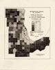
Tuberculosis in a congested district in Chicago, Jan. 1st, 1906, to Jan. 1st, 1908, including the district represented in chart 1, population chiefly Jewish / by Theodore B. Sachs. | Near West Side (Chicago, Ill.)--Maps. Tuberculosis--Illinois--Chicago--Maps. |
Scale [ca. 1:1,200]. [S.l. : s.n., between 1908 and 1919]. 1 map ; 32 x 52 cm. |
 |
Map of Chicago showing land values, 1910 : average values for 960 acre tracts in dollars per acre / [Homer Hoyt]. | Real property--Illinois--Chicago--Maps. | Scale [ca. 1:200,000]. [Chicago : Social Science Research Committee, between 1930 and 1933]. 1 map ; on sheet 28 x 22 cm. |
 |
Seventy statistical areas of Chicago, percentage distribution of Committee of Fifteen cases for 1910 to 1929. | Prostitution--Illinois--Chicago--Maps. | Scale [ca. 1:280,000]. [Chicago : University of Chicago Press, 1933]. 1 map ; 18 x 12 cm. Originally published in: Vice in Chicago / Walter C. Reckless. Chicago : University of Chicago Press, c1933. |
 |
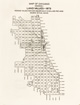
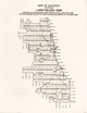
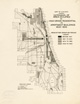
Map no. VII showing places of residence of 7541 alleged male offenders placed in the Cook County jail during the year 1920, 17-75 years of age / prepared by research sociologists ; Behavior Research Fund, Chicago. | Crime--Illinois--Chicago--Maps. Criminals--Illinois--Chicago--Maps. |
Scale [ca. 1:122,500]. [Chicago : University of Chicago Press, 1929]. 1 map ; on sheet 41 x 23 cm. Originally published in: Delinquency areas : a study of the geographic distribution of school truants, juvenile delinquents, and adult offenders in Chicago / Clifford R. Shaw, with the collaboration of Frederick M. Zorbaugh, Henry D. McKay, Leonard S. Cottrell. Chicago : University of Chicago Press, 1929. |
 |
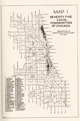
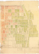
Hyde Park Community / prepared by the Department of Sociology, the University of Chicago. | Hyde Park (Chicago, Ill.)--Maps. | Scale [ca. 1:8,000]. [Chicago : Dept. of Sociology, 192-?]. 1 map : photocopy ; 45 x 45 cm. Blue line print. |
 |
Lawndale Community. | North Lawndale (Chicago, Ill.)--Maps. | Scale [ca. 1:8,000]. [Chicago : Dept. of Sociology, 192-]. 1 map : photocopy ; 43 x 71 cm. Blue line print. |
 |
Lower North Community. | Near North Side (Chicago, Ill.)--Maps. West Town (Chicago, Ill.)--Maps. Loop (Chicago, Ill.)--Maps. |
Scale [ca. 1:8,000]. [Chicago : Dept. of Sociology, 192-?]. 1 map : photocopy ; 45 x 75 cm. Blue line print. |
 |
Pilsen and adjoining neighborhoods / prepared by the Department of Sociology, the University of Chicago ; G.W.W. | Lower West Side Side (Chicago, Ill.)--Maps. | Scale [ca. 1:8,000]. [Chicago : Dept. of Sociology, 192-?]. 1 map : photocopy ; 44 x 68 cm. Blue line print. |
 |
Woodlawn Community / prepared by the Department of Sociology, the University of Chicago. | Woodlawn (Chicago, Ill.)--Maps. | Scale [ca. 1:8,000]. [Chicago : Dept. of Sociology, 192-?]. 1 map : photocopy ; 45 x 62 cm. Blue line print. |
 |
Bridgeport and adjoining neighborhoods / prepared by Department of Sociology, University of Chicago. | Bridgeport (Chicago, Ill.)--Maps. | Scale [ca. 1:8,000]. [Chicago : Dept. of Sociology, 1923]. 1 map : photocopy ; 57 x 41 cm. Blue line print. |
 |
Brighton Park / prepared by Department of Sociology, University of Chicago. | Brighton Park (Chicago, Ill.)--Maps. | Scale [ca. 1:8,000]. [Chicago : Dept. of Sociology, 1923]. 1 map : photocopy ; 62 x 46 cm. Blue line print. |
 |
East and West Garfield Park. | East Garfield Park (Chicago, Ill.)--Maps. West Garfield Park (Chicago, Ill.)--Maps. |
Scale [ca. 1:8,000]. [Chicago : Dept. of Sociology, 1924]. 1 map : photocopy ; 51 x 56 cm. Blue line print. |
 |
Englewood and West Englewood / prepared by Department of Sociology, University of Chicago. | Englewood (Chicago, Ill.)--Maps. West Englewood (Chicago, Ill.)--Maps. |
Scale [ca. 1:8,000]. [Chicago : Dept. of Sociology, 1924]. 1 map : photocopy ; 75 x 64 cm. Blue line print. |
 |
McKinley Park, Chicago, Ill. | McKinley Park (Chicago, Ill.)--Maps. | Scale [ca. 1:8,000]. [Chicago : Dept. of Sociology, 1924]. 1 map : photocopy ; 46 x 59 cm. Negative blue line print. |
 |
East Humboldt Park. | West Town (Chicago, Ill.)--Maps. Logan Square (Chicago, Ill.)--Maps. Humboldt Park (Chicago, Ill.)--Maps. |
Scale [ca. 1:8,000]. [Chicago : Dept. of Sociology, 1925]. 1 map : photocopy ; 60 x 85 cm. Negative blue line print. |
 |
Lakeview and Lincoln. | Lakeview (Chicago, Ill.)--Maps. Lincoln Park (Chicago, Ill.)--Maps. |
Scale [ca. 1:8,000]. [Chicago : Dept. of Sociology, 1925]. 1 map : photocopy ; 51 x 56 cm. Blue line print. |
 |
Chicago's gangland / prepared by Frederic M. Thrasher, 1923-1926. | Gangs--Illinois--Chicago--Maps. | Scale [ca. 1:85,000]. [Chicago : University of Chicago Press, 1936]. 1 map : col. ; 65 x 45 cm. Removed from: The gang : a study of 1,313 gangs in Chicago. 2d. rev. ed. Chicago : University of Chicago Press, 1936. |
 |
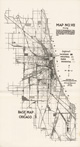
Social base map of Chicago : showing industrial areas, parks, transportation, and language groups / prepared by the University of Chicago Local Community Research Committee. | Ethnology--Illinois--Chicago--Maps. | Scale [ca. 1:87,500]. [Chicago] : University of Chicago Press, 1926. 1 map ; 65 x 45 cm. |
 |
The Near West Side. | Near West Side (Chicago, Ill.)--Maps. | Scale [ca. 1:7,920]. [Chicago : Dept. of Sociology, 1927]. 1 map : photocopy ; 53 x 91 cm. Negative blue line print. |
 |
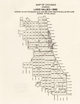
Map no. III showing addresses of 8591 alleged male juvenile delinquents dealt with by the juvenile police probation officers during the year 1927, ten to seventeen years of age / prepared by research sociologists ; Behavior Research Fund, Chicago. | Juvenile delinquency--Illinois--Chicago--Maps. | Scale [ca. 1:122,500]. [Chicago : University of Chicago Press, 1929]. 1 map ; on sheet 41 x 23 cm. Originally published in: Delinquency areas : a study of the geographic distribution of school truants, juvenile delinquents, and adult offenders in Chicago / Clifford R. Shaw, with the collaboration of Frederick M. Zorbaugh, Henry D. McKay, Leonard S. Cottrell. Chicago : University of Chicago Press, 1929. |
 |
Map of Chicago showing land values, 1928 : average values for 960 acre tracts in dollars per acre / [Homer Hoyt]. | Real property--Illinois--Chicago--Maps. | Scale [ca. 1:200,000]. [Chicago : Social Science Research Committee, between 1930 and 1933]. 1 map ; on sheet 28 x 22 cm. |
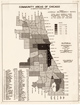 |
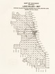
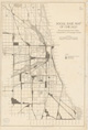
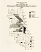
Community areas of Chicago as adopted by Census Bureau, 1930, showing juvenile delinquency rates / map prepared by Louis B. Narowski under direction of Louis Wirth and Nathan Bodin for the Social Science Research Committee, University of Chicago. | Juvenile delinquency--Illinois--Chicago--Maps. | Scale [ca. 1:190,000]. [Chicago : Social Science Research Committee, 193-]. 1 map ; 28 x 22 cm. |
 |
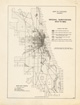
Number of cases of desertion per 100,000 population, 1930 : community areas of Chicago as adopted by Census Bureau, 1930. | Desertion and non-support--Illinois--Chicago--Maps. | Scale [ca. 1:101,400]. Chicago : Social Science Research Committee, [193-?]. 1 map ; 60 x 44 cm. |
 |
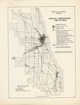
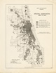
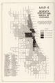
Metropolitan region of Chicago, per cent of population white of native parentage, by townships, 1930 : by sectors and zones in Chicago / map prepared by Richard O. Lang | Ethnology--Illinois--Chicago--Maps. | Scale [ca. 1:1,000,000]. [Chicago] : Social Science Research Committee, 1935. 1 map ; 21 x 18 cm. |
 |
Seventy five local communities in Chicago, distribution of Committee of Fifteen cases for 1930. | Prostitution--Illinois--Chicago--Maps. | Scale [ca. 1:280,000]. [Chicago : University of Chicago Press, 1933]. 1 map ; 18 x 12 cm. Originally published in: Vice in Chicago / Walter C. Reckless. Chicago : University of Chicago Press, c1933. |
 |
East 63rd Street : Cottage Grove Ave. to Stony Island Ave. | Woodlawn (Chicago, Ill.)--Commerce--Maps. | Scale [1:600]. [Chicago : University of Chicago, Dept. of Sociology?, 193-?]. 1 map : photocopy ; 285 x 38 cm. Blue line print. |
 |
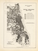
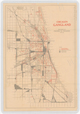
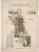
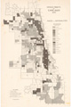
Map of Chicago, showing types of cultural and economic areas / adapted from maps prepared by the Social Science Research Committee, the University of Chicago. | Human geography--Illinois--Chicago--Maps. Land use--Illinois--Chicago--Maps. |
Scale [ca. 1:190,000]. [Chicago : Social Science Research Committee, between 1930 and 1933]. 1 map ; 24 x 18 cm. |
 |
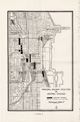
Map of Chicago, showing extension of area occupied by high grade residential or apartment buildings, 1833-1933. | Apartment houses--Illinois--Chicago--Maps. Housing--Illinois--Chicago--Maps. Land use--Illinois--Chicago--Maps. |
Scale [ca. 1:190,000]. [Chicago : Social Science Research Committee, 1933?]. 1 map ; 24 x 18 cm. |
 |
Map of Chicago, showing extension of area occupied by manufacturing and industrial buildings, 1833-1933. | Industries--Illinois--Chicago--Maps. Land use--Illinois--Chicago--Maps. |
Scale [ca. 1:190,000]. [Chicago : Social Science Research Committee, 1933?]. 1 map ; 24 x 18 cm. |
 |
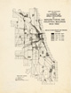
Map of Chicago showing area occupied by predominant racial or nationality groups, 1933. | Ethnology--Illinois--Chicago--Maps. | Scale [ca. 1:200,000]. [Chicago : Social Science Research Committee, between 1930 and 1933]. 1 map ; on sheet 28 x 22 cm. |
 |
Map of Chicago showing distribution of buildings seven stories high or over, 1933. | Skyscrapers--Illinois--Chicago--Maps. | Scale [ca. 1:200,000]. [Chicago : Social Science Research Committee, between 1930 and 1933]. 1 map ; on sheet 28 x 22 cm. |
 |
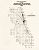
Census tracts of Chicago, 1940. Races and nationalities. | Ethnology--Illinois--Chicago--Maps. Immigrants--Illinois--Chicago--Maps. |
Scale [ca. 1:50,000]. [Chicago] : Social Science Research Committee, University of Chicago, [1940?]. 1 map ; 87 x 56 cm. |
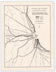 |
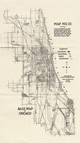
Passenger train movement in metropolitan Chicago / Harold M. Mayer. | Railroads--Illinois--Chicago--Maps. | Scale [ca. 1:230,000]. [Chicago : s.n., 1943]. 1 map ; 50 x 38 cm. |
 |
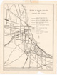
Principal railway facilities in central Chicago / [Harold M. Mayer] ; base map by Chicago Land Use Survey. | Railroads--Illinois--Chicago--Maps. Central business districts--Illinois--Chicago--Maps. |
Scale [ca. 1:18,000]. [Chicago : s.n., 1943]. 1 map ; 43 x 28 cm. |
 |
Pattern of railway facilities in Chicago and vicinity / Harold M. Mayer. | Railroads--Illinois--Chicago--Maps. | Scale [ca. 1:130,000]. [Chicago : s.n.], 1943. 1 map ; 56 x 43 cm. |
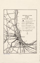 |
Functional pattern of the railways in Metropolitan Chicago / Harold M. Mayer. | Railroads--Illinois--Chicago--Maps. | Scale [ca. 1:580,000]. [Chicago : s.n.], 1943. 1 map ; 30 x 23 cm., on sheet 44 x 28 cm. |
 |
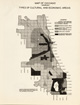
[Map showing change in white and non-white population in Hyde Park, 1950-1956] / map prepared by Sol Tax for paper on problems of the local community, given Feb. 4, 1957 ; data from urban renewal survey, N.O.R.C., & Chic. Community Inventory. | Ethnology--Illinois--Chicago--Maps, Manuscript. Hyde Park (Chicago, Ill.)--Maps, Manuscript. Kenwood (Chicago, Ill.)--Maps, Manuscript. |
Scale [ca. 1:5,800]. [1957]. 1 map : ms., col. ; 77 x 103 cm. |